Survival Valley - A hidden green basin in Phong Nha–Ke Bang
02-01-2026 12:10
Main contents
Where is Survival Valley – Aquarium Cave?
Survival Valley lies about 15 km south-west of Phong Nha Cave, and roughly 4 km east of Moọc Spring. Within the valley are Cave E (also known as Aquarium Cave / Hang Thuỷ Cung) and Dark Cave (also known as Diving-Water Cave / Hang Nước Lặn). Between these two caves runs Trẹ Stream, nearly 2 km long.
Survival Valley can be pictured as a vast green basin, enclosed by towering limestone walls—where water from both surface streams and underground sources converges and feeds the cave systems below.
Nature “wrapped” inside Survival Valley
Survival Valley is not merely a place name. It feels like a miniature conservation core, holding outstanding values in both geology and biodiversity. Covering around 2,000 hectares, the valley forms a distinctive basin-shaped landform, functioning as a major water-collecting catchment for the surrounding limestone massif. It is also where five ancient geological formations meet—evidence of key chapters in Earth’s long development.
The delicate connection of Trẹ Stream flowing between Cave E and Dark Cave not only creates poetic scenery—clear pools and quiet bends—but also reveals the craftsmanship of karstification. In particular, this landscape reflects processes associated with the third cave level, shaped over millions of years.
The valley’s value is also present in its richness of essential natural habitats for threatened species. It supports a dense, multi-layered plant community of 142 recorded species, from large buttressed trees such as Sấu and Trường, to precious medicinal plants listed in Vietnam’s Red Data Book, including Giảo cổ lam and Hoàng đằng. Notably, the area provides refuge for rare primates such as the white-cheeked gibbon langur (Voọc gáy trắng / Voọc Hà Tĩnh) and the red-shanked douc langur (Chà vá chân nâu), along with endemic species like the Phong Nha–Kẻ Bàng gecko—together forming a highly sensitive ecological network that requires strict protection from human pressures.
To appreciate Survival Valley is to appreciate a living heritage: every underground stream, every steep limestone wall carries a quiet mission—sustaining biodiversity within the wider karst landscape.
In that sense, Survival Valley is a hidden green heart within the heritage site—where the “veins” are underground waters continuously flowing, keeping the surrounding karst ecosystem alive.
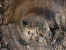
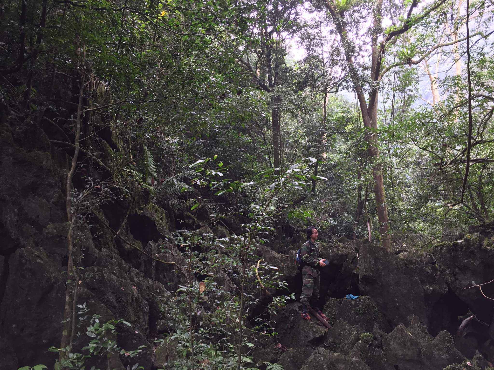 A survey in Sinh Ton Valley. By Phong Viet
Weather and hydrology: the valley’s pulse
Survival Valley bears the tropical monsoon character typical of the Phong Nha–Kẻ Bàng limestone mountains, with noticeable temperature variation and a complex hydrological system.
Based on observation data, the annual average temperature is around 23–25°C. Two seasons are distinct:
Hot season (April–October): average temperatures above 25°C, with peaks up to 41.6°C under the influence of hot, dry south-westerly winds.
Cool season (November–March): average around 20°C, with the lowest recorded down to 5.5°C.
Humidity remains high, roughly 73–90%. Annual rainfall is substantial—about 2,000–2,500 mm—with around 88% falling during the wet season (May–December), especially September to November. This is also when storms frequently affect the valley, leading to tree falls and localised landslides where geological conditions are unstable.
For explorers, there is a distinctive feel to the valley’s microclimate: it often seems warmer in winter and cooler in summer, likely moderated by the basin topography, limestone walls, and the presence of water.
Hydrologically, the valley acts as a major catchment funnel for the surrounding limestone massif. Water here alternates between surface flow and subterranean flow through the caves. The main feature is Trẹ Stream (nearly 2 km), running from Cave E (Aquarium Cave) towards Dark Cave (Diving-Water Cave). Water emerging at Cave E is described as being supplied by underground streams associated with the Sơn Đoòng cave system; after crossing the valley, it sinks into Dark Cave and ultimately joins the Chày River.
Flood season (September–November): water levels rise quickly, producing flash flooding in places, but also recede quickly due to the cave drainage network.
Dry season (February–July): discharge may account for only 20–24% of the annual total.
Survival Valley can therefore be seen as nature’s giant funnel—receiving tropical downpours and circulating water through hidden underground “arteries” that sustain life across the heritage ecosystem.
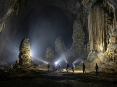
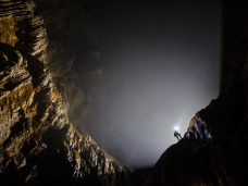
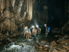
 Thuy Cung Cave. By Phong Viet
Geological history: a stone chronicle
Survival Valley is like a stone chronicle, where each layer of rock reads as a page recording Earth’s changes—from the Devonian (around 419 million years ago) to the end of the Cretaceous (around 66 million years ago).
The area spans five geological formations: Động Thờ, Cát Đằng, La Khê, Bắc Sơn, and Mụ Giạ. Most notable is the Bắc Sơn Formation, featuring massive limestone and siliceous limestone with a thickness of roughly 600–1,000 m. In contrast, the Mụ Giạ Formation is characterised by reddish-brown sediments such as conglomerates and coarse-grained sandstones. This diversity creates a complex geological foundation, interweaving siliciclastic sediments and carbonate rocks.
The valley itself forms a broad, fairly flat basin of about 2,000 hectares, encircled by steep limestone mountains. Elevation ranges from roughly 10 m to 400 m, where limestone karst, soil-covered hills, and alluvial deposits of sand and gravel meet along the stream corridor.
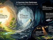
Geological value is further expressed through an interconnected underground cave network. Dark Cave (Diving-Water Cave) and Cave E (Thuy Cung Cave) are identified as part of the third cave level within a system described as having six levels of cave development. On the valley floor, remnants of weathering remain—large isolated limestone blocks and loose sediments such as fine sands—transported and deposited by surface streams and subterranean flows over millions of years. These features make the valley a living natural museum of karst evolution.
In short: ancient strata, fractured and eroded over deep time, have given rise to a green basin—while beneath it, underground “veins” continue to thread through the limestone ranges.
Biodiversity: essential habitat within the heritage site
Survival Valley holds biodiversity of high conservation significance within the Phong Nha–Kẻ Bàng World Natural Heritage landscape. It aligns with UNESCO-recognised values as an outstanding example of ecological processes and as an area containing essential natural habitats for biodiversity conservation.
Flora: 142 species across 63 families, typical of humid tropical evergreen forests on both soil-covered hills and limestone karst, structured into three distinct layers. Several species are listed as rare, including Cốt toái bổ, Giảo cổ lam, Hoàng đằng (Vietnam Red Data Book) and Trường mật, Muồng chằn (IUCN listings).
Fauna: notable threatened primates such as Voọc gáy trắng (Voọc Hà Tĩnh), red-shanked douc langur, and red-faced macaque, along with other important species including the Phong Nha–Kẻ Bàng gecko and the horned pit viper.
Aquatic life: the Trẹ Stream–cave habitat supports 13 aquatic species, including the giant mottled eel (cá chình hoa), described as near-threatened/vulnerable.
Protecting these values is essential to maintaining the integrity of the heritage ecosystem in the face of tourism and development pressures.
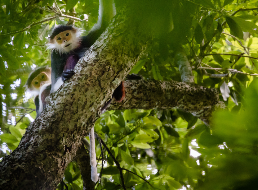 Douc Langur a primate species found in Sinh Ton Valley. By Ryan
Scenic value: where stillness meets motion
Survival Valley offers striking, monumental scenery—an emblematic expression of Phong Nha–Kẻ Bàng’s unique beauty. Its closed basin form (around 2,000 ha) creates an embracing space: a relatively level valley floor enclosed by high limestone cliffs that drop steeply into the basin.
Its aesthetic appeal comes from the interplay of landforms—grey-white limestone mountains, lush green soil hills, alluvial flats, and the clear ribbon of Trẹ Stream connecting Cave E and Dark Cave. At key points, the landscape feels like a sequence of vivid natural frames:
Ecological lake: a clear pool of about 400 m², surrounded by large boulders and shaded by old fig trees spreading out over the water.
Cave entrances: Cave E (Aquarium Cave) with fine sandy ground and large residual limestone blocks; Dark Cave (Diving-Water Cave) set against a near-vertical cliff where the stream disappears underground—mysterious and dramatic.
Forest cover: rich forests on soil hills with buttressed trees such as Sấu and Trường, with low branching forms that are visually distinctive—well suited, if carefully planned, to low-impact ecotourism experiences.
Overall, the valley is a dialogue between stillness—million-year limestone walls—and movement—water that never stops flowing, sustaining a dense, multi-layered tropical forest ecosystem.
Survival Valley truly is a hidden “green basin” within limestone walls—where every viewpoint blends forest green, stone grey, and the crystal clarity of underground water.
Comments
Comments (Total 0)
Related Articles

19-06-2026
MINI GAME CHINH PHỤC CỒN CỎ
24-04-2026
DMZ Vietnam Travel Guide 2026


12-12-2025