A Journey on Hac Hai lagoon
01-04-2024 08:34
This journey intrigued me because of the phrase "The Dau Mau mountains rise tall like a writing brush and the Hac Hai lagoon spread wide like a vast inkwell" and the fact that some of my friends had made their first steps to breathe life into this land. The boat picked us up at Moi pier, in Hong Thuy commune, following a canal westward for over 1km until we reached the Kien Giang river. In this position, the river widens to about 200m, with deep blue-green waters in the middle and it is possibly quite deep. This area has basin terrain with the terrain getting higher when we move outward. To the east, in the distance, were sand dunes stretching along the coast, about 12 to 30 meters high. From the South to the North, we have Hong Thuy and Gia Ninh communes. To the west lay vast fields, beyond which were tall mountain ranges under 300 meters, belonging to Hoa Thuy and Van Ninh communes. Upstream to the south is the marshy area belonging to An Thuy and Loc Thuy communes. Downstream to the north, it merged with the Long Dai river before flowing into the parent river, Nhat Le.

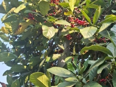
Mangrove, a type of salt-tolerant plant that remains. Photo by Văn Trí Võ
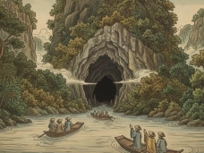
Navigating along the lagoon, we encountered some trees on the banks which were submerged in water. When looking closer, these were seemingly aged (possibly older than a century) large sonneratia caseolaris. These trees reminded me about the sonneratia caseolaris forests in Xuan Thuy, Nam Dinh, and Ca Mau province that I had visited. My mind suddenly wondered if this place was a vast mangrove forest teeming with sonneratia caseolaris , avicennia marina, along with flocks of birds and schools of fish many years ago? Did the records of Hac Hai's past nestled within ancient historical documents? In “ O chau can luc '' by Duong Van An under the reign of Mac Phuc Nguyên in 1555, it is noted that :Thien Hai recieves water from sources in An Sinh and Cam Ly, Le Thuy district. This is the place where hundreds of rivers sconverge, all streams pour in, hence its other name is Hac Hai which means the shallow sea. To the northeast, the sea is vast and blue with many sand dunes ; to the southwest, mountains stand like screens, protruding like swords. The water surface is immense like the silver sea and clear like jade fields. Clams and fishes thrive while storks fly and wade. Small boats and fishing boats sail among the mountains and lakes, brimming with moon and wind, reaching the level of Ngu Ho." These lakes stretch out in vast expanse, surrounded by both deep and shallow mounds. In the middle, there is only a very deep waterway, making boat navigation difficult, especially at night. The "Dai Nam Nhat Thong Chi," book of the Nguyen dynasty during the reign of Tu Duc in 1882, states: " Thach Ban lagoon, located 14 miles north of Le Thuy district, is called Thien Hai, also known as Binh Ho, where water from the Yen Sinh and Cam Ly sources converges, gathering hundreds of rivers and streams, forming what is called Hac Hai. To the northeast, sand dunes pile up, while to the northwest, countless mountains block the way, with both deep and shallow areas, and a very deep waterway where boats must be cautious of rough waves; the downstream flows into the My Huong River before pouring into the sea."
In the "An Nam chi" (Geography of Annam), it is recorded that: "Thien Hai, located in Nha Nghi district, is surrounded by vast marshlands, dense reeds, waterfowl floating and diving, fishing nets gathering, potentially serving as a place for cruising." Indeed, the ancients have described and recorded, though not in detail, giving us an insight into the riverine landscape and the ecological scenery of a flooded forest area, rich in resources, serving as a waterway transportation route, livelihood for the people, as well as a place worth exploring. It is a very special geographical area located in the southern part of Vietnam in the 14th century and later in the Central region.

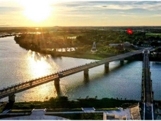
Sunset over Hạc Hải Lagoon - Photo by Văn Trí Võ
Passing through the waterways and the fields after harvest, to me, Hac Hai seems like a reservoir, half natural, half artificial. This is due to the My Trung damp, built to prevent saltwater intrusion, disrupting the natural rhythm of the tides. The salinity of the water here is very low, only about one thousandth, leading to significant ecological changes. The plant species indicate that this area owns brackish environments with typical salinity levels between 15-25%. Perhaps the process of freshwater intrusion along with human exploitation has led to the drastic reduction of vegetation. Along the riverbanks, there are few sonneratia caseolaris, or avicennia marina, only clusters of reeds, grasses remain. Once the habitat is lost, surely the animals have no place to shelter, leading to the disruption of the food chain, making it difficult for species to find habitats and food. According to stories, in the past, this place used to be a haven for birds and fish, they were present in every season, providing sustenance for the locals, who could easily catch shrimp and fish for a meal. Just find a spot, cast a net, then you could have caught too many fishes that you may need an hour to entangle them out the net. Sometimes crabs would wander into the backyard due to the water shock while varunidaes are formed into rafts of dozens of square meters that people ignore. Perhaps at that time, this area was an ideal habitat for various aquatic species and maybe Hac Hai, once compared to an inkwell by the ancients, was home to countless aquatic species. Now it is very different but the natural landscape still allows for reminiscence and nurturing.
Together with those who are attached to Hac Hai and cherish this land, we brainstorm ideas to bring back the birds, to make the waters a habitat, a place for the younger generation to understand nature better. We will delve deeper into ecology, hydrology, geology, culture, to provide deeper insights into approaches and actions, to bring Hac Hai back to its true essence.
Văn Trí Võ
Comments
Comments (Total 0)
Related Articles

19-06-2026
MINI GAME CHINH PHỤC CỒN CỎ

24-04-2026
DMZ Vietnam Travel Guide 2026


12-12-2025