


New Quang Tri – A United Land of Shared Aspirations
24-06-2025 17:00
1. Overview
1.1 Formation
On 16 June 2025, the Standing Committee of the National Assembly issued Resolution No. 1680/NQ-UBTVQH15, approving the merger of Quang Binh and Quang Tri into a new administrative unit under the name Quang Tri. The resolution also involved the reorganisation and consolidation of numerous commune-level administrative units to streamline local governance. The provincial administrative structure now follows a two-tier model. Many small communes were merged and renamed; for instance, four communes in Quang Binh—Quang Hoa, Quang Loc, Quang Van, and Quang Minh—were combined into Nam Gianh Commune, while five others—Quang Tan, Quang Trung, Quang Tien, Quang Son, and Quang Thuy—became Nam Ba Don Commune. In Quang Tri, neighbouring localities were also consolidated: Ho Xa township and the communes of Vinh Long and Vinh Chap were unified into Vinh Linh Commune, while Cua Tung township was merged with Vinh Giang, Hien Thanh, and Kim Thach to form Cua Tung Commune.
The new province now comprises 69 communes, 8 wards, and 1 administrative unit—Con Co Island—which has been reclassified as the Con Co Special Zone. This brings the total number of commune-level administrative units in the new Quang Tri province to 78, a significant reduction from the previous total of 264 units in the former Quang Binh (145) and Quang Tri (119). Resolution 1680 took effect immediately upon approval (16 June 2025) and required completion of all transitional arrangements by 1 July 2025, including the measurement and demarcation of new administrative boundaries.
1.2 Administrative Boundaries after the Merger
Post-merger, the new Quang Tri province lies within Vietnam’s North Central Region, stretching from the border with Ha Tinh in the north to Hue in the south. It borders Laos to the west and the East Sea to the east, and sits on the strategic North–South transport corridor (approximately 500 km from Hanoi and 1,070 km from Ho Chi Minh City via National Highway 1A). The newly formed province covers a natural area of around 12,700 km² and has a population of nearly 1.87 million. This makes Quang Tri the 10th largest province in Vietnam by area, and approximately 23rd in terms of population.
1.3 Population, Area, and Economic Output
Before the merger, Quang Binh covered 8,065 km² with a population of about 1.08 million, while Quang Tri spanned 4,701 km² and had a population of approximately 791,000 in 2024. Following the merger, both area and population significantly increased. The 2024 Gross Regional Domestic Product (GRDP) of Quang Binh was estimated at VND 60.18 trillion, while Quang Tri's was estimated at VND 53.5 trillion, bringing the combined total to approximately VND 113.7 trillion. This places the new province around 26th among Vietnam's 63 provinces and municipalities in terms of economic scale.
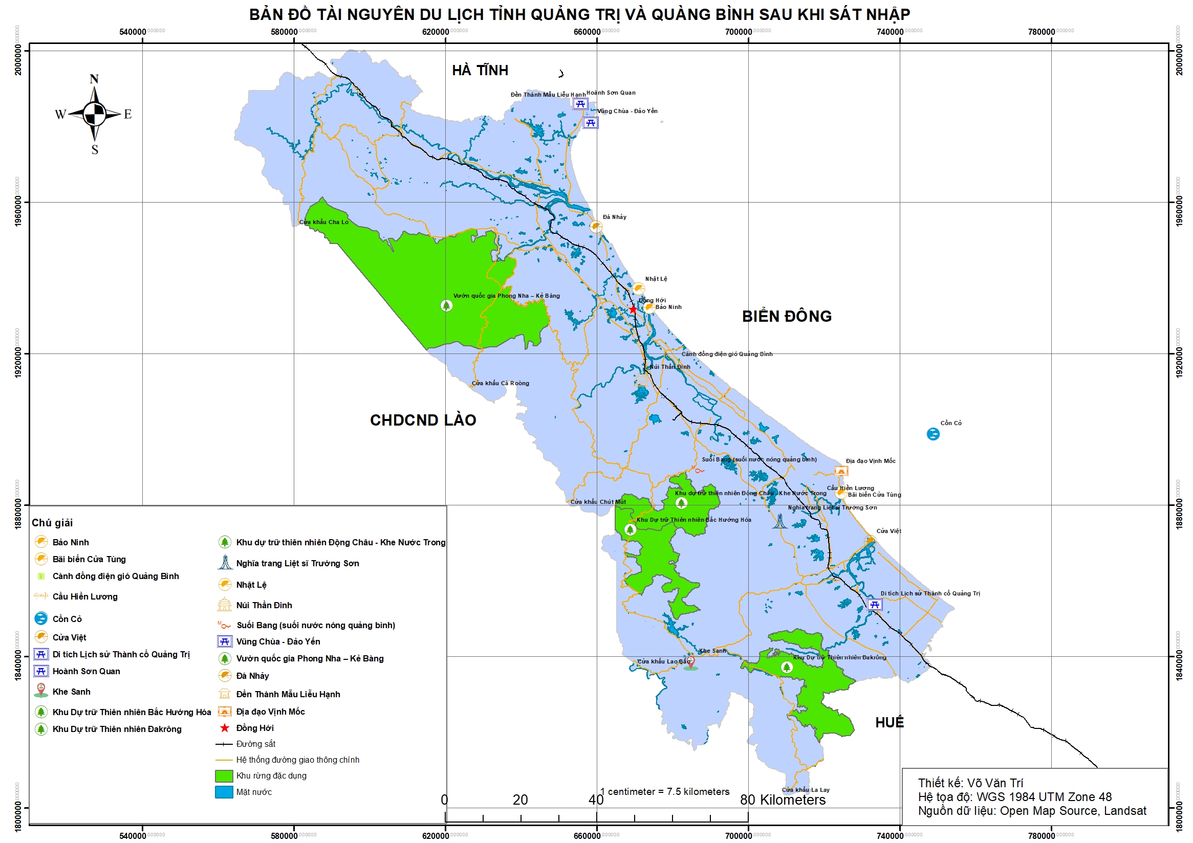 Tourism captital resource map of Quang Trị
2. Natural Resources
2.1 Topography
The newly unified Quang Tri province features a narrow, elongated terrain extending north to south, with the Truong Son mountain range in the west and coastal plains to the east. The province has well-defined elevation zones: high mountains along the Vietnam–Laos border (with many peaks ranging from 1,000 to 2,000 metres), midlands with hills, and low-lying coastal plains. Quang Binh is well known for its Phong Nha–Ke Bang limestone region (a UNESCO World Heritage Site), home to the world’s largest cave, Son Doong. Quang Tri includes highland plateaus in Huong Hoa and Dakrong, and narrow plains in the coastal districts of Trieu Phong and Hai Lang. In general, the two former provinces share similar natural conditions, and their unification results in a province encompassing all topographical features—from high mountains and ancient forests to midlands, plains, and islands [3].
2.2 Climate
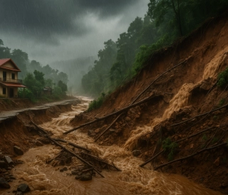
The province is entirely within the tropical monsoon climate zone of North Central Vietnam. It is characterised by hot, dry summers and stormy, rainy autumns. From May to August, hot dry foehn winds from the southwest (locally known as the Lao winds) can push temperatures above 40°C. From September to December, storms from the East Sea bring heavy rainfall, often causing floods in river systems. Both Quang Binh and Quang Tri are frequently affected by severe weather events, such as the devastating floods of October 2020. The average annual temperature is approximately 24–25°C, with humidity around 84%. In the mountainous west, the climate is cooler and the winters are relatively mild.
2.3 Rivers
The new province’s river system consists of short, steep rivers flowing from the Truong Son range to the sea. Major rivers include the Gianh River (~160 km) and the Nhat Le River in Quang Binh (formed by the confluence of the Kien Giang and Long Dai Rivers, flowing through Dong Hoi), the Thach Han River (~150 km, running through Dong Ha in Quang Tri), and the Ben Hai River, historically associated with the 17th parallel. Numerous smaller rivers and streams also crisscross the region—Rao Nan, Rao Tro (Quang Binh); Hieu River, O Lau River (Quang Tri). Although short, these rivers have large mountainous catchments and can rise rapidly during the flood season, emptying into the sea through estuaries like Nhat Le, Cua Viet, and Cua Tung.
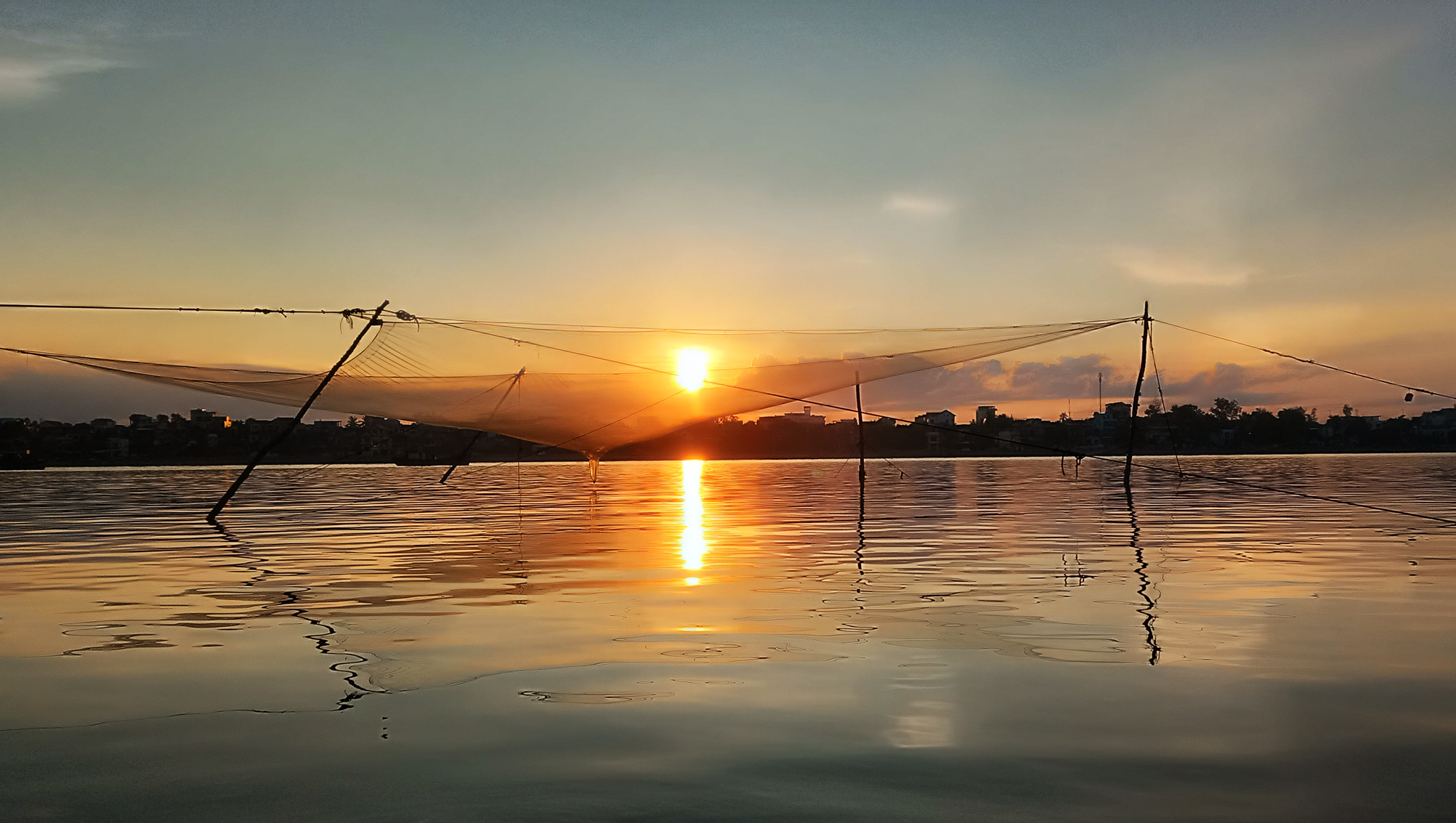 On the Nhat Le River – Photo by Tue Minh
2.4 Forest and Marine Resources
The new Quang Tri province possesses rich ecosystems encompassing forests, islands, and caves. The Phong Nha–Ke Bang National Park and associated nature reserves form a critical biodiversity and landscape conservation network. The province features a 200 km coastline with beautiful sandy beaches, such as Nhat Le, Quang Phu, Da Nhay, and Cua Tung—once known as the "Queen of Indochinese beaches"—as well as the unspoiled beaches of Cua Viet and Mui Treo. The coastal waters offer fertile fishing grounds and abundant mineral resources like titanium-bearing sands. Con Co Island, off the coast of Quang Tri, boasts a diverse marine ecosystem, supporting island tourism and fisheries logistics. Coastal resources also present strong potential for renewable energy development.
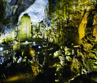
Phong Nha–Ke Bang is a UNESCO World Heritage Site recognised for its geological, ecological, and biodiversity significance. The park includes approximately 1,000 limestone caves, primary rainforest home to around 2,900 plant species and over 1,300 animal species, including many rare ones. Of note is its primate population—11 species, including the endemic white-cheeked gibbon. The tropical forest ecosystem plays a key role in climate regulation, water source protection, and international eco-tourism.
Dong Chau–Khe Nuoc Trong Nature Reserve spans 22,132 ha of remaining primary Truong Son forest. The area is rich in caves, pristine streams, and is a habitat for numerous primate species, forest birds, and endemic flora. It serves as a vital biological corridor connecting Phong Nha and ecosystems in Quang Tri.
Bac Huong Hoa Nature Reserve contains 283 plant species (59 rare) and diverse fauna, including 109 mammals, 207 birds, 81 reptiles–amphibians, and 33 fish species. The region’s elevation (150–1,700 m) supports multi-layered forest ecosystems, from subtropical to tropical rainforests. Notable species include the white-crested pheasant, saola, and Ha Tinh langur. The reserve also plays a key role in protecting the headwaters of the Ben Hai, Rao Quan, Hieu, and Se Pang Hien Rivers.
Dakrong Nature Reserve, covering 37,841 ha across seven southern communes, houses 1,412 plant species (24 in Vietnam's Red Book) and 612 animal species (37 Red Book-listed). This area represents typical low mountain biodiversity in northern Truong Son, with rugged terrain and many streams, suitable for community-based eco-tourism.
The Con Co Island Marine Reserve, established in 2009 and covering 4,532 ha, protects 113 coral species, 224 marine fish species (49 of commercial value), sea turtles, dolphins, and a rich benthic fauna.
Collectively, these reserves form a continuous ecological network from mountainous forests to offshore islands. They underpin strategies for eco-tourism, scientific research, environmental conservation, and sustainable green development.
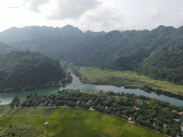 Phong Nha. Photo by Tue Minh
2.5 Mineral Resources
The new Quang Tri province holds a diverse but small-scale array of mineral resources. Quang Binh is home to large limestone and clay deposits used in cement production (e.g. the Hoang Mai deposit in Quang Trach), as well as granite and precious stones in the western region. Quang Tri has silica sand deposits in Cam Lo, small placer gold reserves in Dakrong, construction stone in Dong Ha, and peat in Hai Lang. Notably, coastal sands along Quang Binh–Quang Tri contain titanium (TiO₂), offering significant industrial potential. In addition, natural hot springs—such as Bang in Quang Binh—provide resources for spa and wellness tourism.
In short, the new Quang Tri province boasts diverse natural conditions—"golden forests and silver seas"—with a strategically important geographic location. These advantages lay a strong foundation for the development of agriculture, forestry, fisheries, eco-tourism, and the marine economy in the years to come [3].
3. Socio-Economic Landscape of the New Province
3.1 Agriculture
Agriculture remains a vital economic foundation for the new province, with fertile farmland stretching from the Gianh and Nhat Le River deltas (Quang Binh) to the Thach Han and O Lau River plains (Quang Tri). Two major rice-growing zones stand out: the Le Thuy – Quang Ninh delta in Quang Binh, known for its high-quality aromatic Le Thuy rice, and the Trieu Phong – Hai Lang plain in Quang Tri, famed for Hai Lang rice. The combined annual rice output is estimated at over 500,000 tonnes.
Rubber is another strength, particularly in the hilly regions of Quang Ninh (Quang Binh) and in Vinh Linh and Cam Lo (Quang Tri), with tens of thousands of hectares under latex-producing rubber trees. Quang Tri’s pepper, especially the spicy-scented Cua pepper (Cam Lo and Vinh Linh), was once a prized export. Arabica coffee thrives in the Khe Sanh highlands (Huong Hoa, Quang Tri), producing high-quality beans under the "Khe Sanh Coffee" brand.
In addition, the province hosts diverse fruit and vegetable zones: dragon fruit, pineapple, banana, cassava, and rubber in Quang Binh; citrus fruits, passion fruit, and honey bananas in Quang Tri. Fisheries hold vast potential, including inshore fishing (fish and squid), whiteleg shrimp farming on coastal sands (Quang Duong in Quang Binh; Gio Linh in Quang Tri), and freshwater fish farming in irrigation lakes.
Unification expands the agricultural landscape, enabling the development of larger specialised production areas and more efficient agricultural value chains.
3.2 Industry and Energy
Although industry in both former provinces was relatively small in scale, unification now lays the groundwork for an integrated energy–industrial hub in the North Central Region. Key projects include the Quang Trach Power Centre in Quang Binh (~1,200 MW coal-fired power plant under construction) located near Hon La port (3). Meanwhile, Quang Tri is planning the Quang Tri Energy Centre in Hai Lang District, with proposed LNG and coal-fired plants, though further investment is still being sought.
Wind power has emerged as a regional strength. In Huong Hoa (Quang Tri), dozens of hilltop wind farms are operational, harnessing year-round mountain winds, with a combined capacity of approximately 350 MW. Quang Binh also holds potential for wind and solar energy development along the sandy coastlines of Le Thuy and Quang Ninh.
Mining and construction materials are also significant: the province is home to cement plants (Song Gianh and Van Hoa in Quang Binh), brick and tile factories, granite workshops, and timber processing units. Industrial parks such as Tay Bac Dong Hoi and Hon La (Quang Binh), along with Nam Dong Ha and Quan Ngang (Quang Tri), form a synergistic network for investment attraction.
The province also lies on the North–South national energy corridor, intersected by 500kV and 220kV transmission lines, facilitating grid connection for locally generated electricity. Overall, the merger allows for a concentration of resources to boost industrial growth and increase the sector’s contribution to the provincial economy.
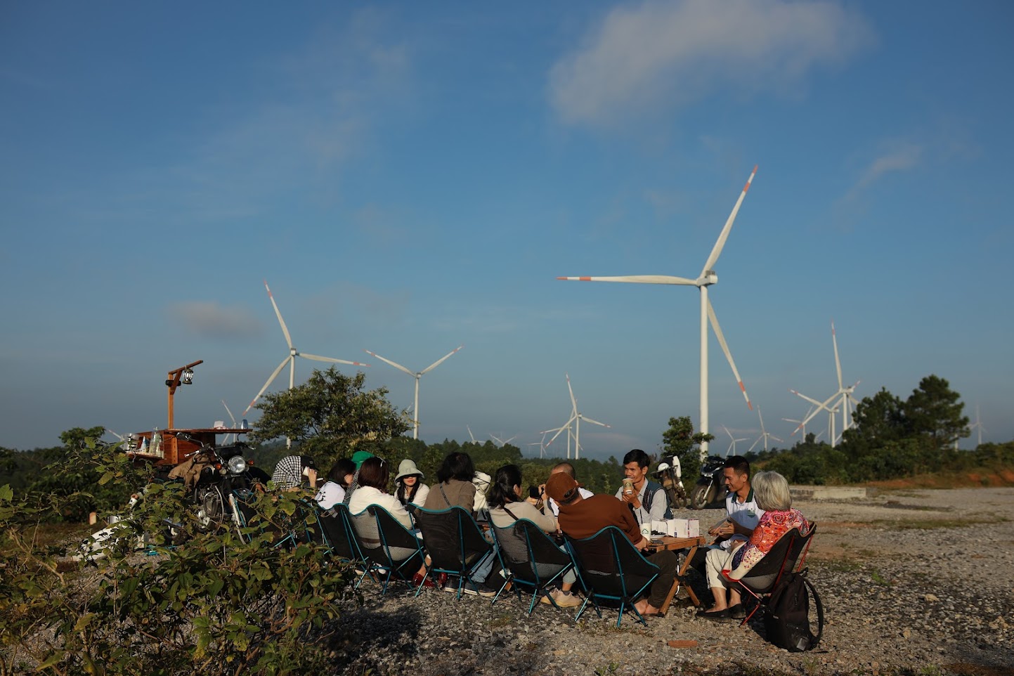
Khe Sanh Wind Farm Hills – Photo by Huy Vo
3.3 Services and Tourism
The expansion in provincial scale offers a significant advantage for service-sector growth. Quang Binh has already established itself on Vietnam’s tourism map as the "kingdom of caves," attracting over 5 million visitors and VND 6 trillion in revenue in 2024 (5), surpassing pre-pandemic records.
Its crown jewel is Phong Nha–Ke Bang National Park, home to breathtaking caves like Phong Nha, Paradise, and Son Doong, which draw domestic and international travellers alike. Other top destinations include Vung Chua–Yen Island, the Dong Chau–Khe Nuoc Trong Nature Reserve, beach tourism hotspots (Da Nhay, Nhat Le, Bao Ninh), and sites of spiritual and cultural interest (Hoang Phuc Pagoda, Temple of Mother Lieu Hanh, Non Pagoda – Than Dinh Mountain).
While Quang Tri’s tourism sector is less developed, it offers rich historical and cultural landmarks: Quang Tri Citadel, Vinh Moc Tunnels, Hien Luong–Ben Hai banks (a symbol of reunification), the Truong Son Martyrs' Cemetery, and Khe Sanh–Ta Con battlefield. These serve as powerful anchors for remembrance tourism and historical education. Other notable sites include the La Vang Holy Land (a revered Catholic pilgrimage site), the Reunification Festival at Hien Luong Bridge (30 April annually), and the beaches of Cua Tung and Cua Viet.
Post-merger, the province has the opportunity to develop cross-regional tours that connect Quang Binh’s natural heritage with Quang Tri’s historical legacy—creating a diverse tourism experience combining sea, forests, caves, and history. The aim is to make tourism a key economic sector worthy of the region’s potential. Beyond tourism, other services such as trade, finance, transport, telecommunications, hospitality, and gastronomy are expected to flourish, supported by the province’s growing market and strategic location along regional trade corridors (3).
Tourism sites in Quang Tri - created by Tue Minh
3.4 Border Trade and Logistics
The new province controls two of the most vital international border gates on the East–West Economic Corridor (EWEC), connecting Laos and Thailand to the East Sea: Cha Lo (Quang Binh) linking to Khammouane Province (Laos) via National Highway 12A, and Lao Bao (Quang Tri) linking to Savannakhet (Laos) via National Highway 9. These routes respectively lead to Vientiane and Bangkok (via Cha Lo), and to Pakse and Bangkok (via Lao Bao), with onward routes to Da Nang Port.
Trade activity at these crossings is vibrant, involving timber, minerals, agricultural products, and consumer goods. The La Lay border gate (Quang Tri), connecting to Salavan (Laos), is also being upgraded. Unification enables the consolidation of resources for more cohesive border-zone economic development.
Lao Bao (Quang Tri) is already a Special Economic and Trade Zone with various incentives for investment in manufacturing, warehousing, and logistics. Meanwhile, the Cha Lo border economic zone (Quang Binh) is under planning. These zones are poised to become critical logistics hubs, positioning the new Quang Tri province as a gateway for goods transshipment across the North Central Region and Indochina.
3.5 Transport Infrastructure
The province lies on Vietnam’s vital North–South transport axis and serves as a maritime gateway for central Laos and northeastern Thailand. Major transport routes include National Highway 1A and the North–South railway running through Dong Hoi and Dong Ha, forming the primary North–South corridor. The Ho Chi Minh Road (with eastern and western branches) runs through mountainous areas—eastern branches through Phong Nha and Khe Sanh, western branches skirting the border—creating a second main axis.
The North–South Expressway (eastern section) passing through Quang Binh and Quang Tri is under construction and expected to open before 2026, significantly reducing interprovincial travel time. The Cam Lo–La Son Expressway (a segment of the western corridor) has already completed its Cam Lo–Dong Ha section and will eventually link to Hue city.
Other vital cross-province roads include National Highways 9 (Dong Ha to Lao Bao, EWEC), 12A (Dong Hoi to Cha Lo), 15 (part of the Ho Chi Minh Road), and Highways 9B and 9C for intra-provincial connections. Waterways such as the Nhat Le, Gianh, and Thach Han rivers are navigable but limited due to short lengths and rapids.
3.6 Seaports
The new province boasts access to the East Sea through a growing seaport system. Quang Binh’s Hon La Port (Quang Trach) is a deep-water port (~15 m depth) capable of handling large bulk carriers. It currently serves bulk cargo (coal, clinker, general goods) and is the import terminal for fuel to the Quang Trach Power Plant. The province also operates smaller ports like Gianh River Port and Nhat Le Port for domestic shipping and fishing.
In Quang Tri, Cua Viet Port (Quang Tri Town) is a multipurpose facility handling vessels of up to 5,000 tonnes and is undergoing expansion. Most notably, the My Thuy Deep Sea Port (Hai An, Hai Lang) has begun construction with 10 planned berths, designed to receive 100,000-tonne ships. Once phase one is completed (expected post-2025), it will serve as a strategic gateway for the East–West Corridor.
Furthermore, the Nhat Le–Hon La area could host large-scale tourism and fishing ports (Nhat Le is currently a class I fishing port in the North Central Region).
3.7 Aviation
At present, the province has Dong Hoi Airport (Quang Binh), a domestic class 4C facility with a 2,400 m runway. It operates flights to Hanoi and Ho Chi Minh City, and during peak seasons to Da Nang and Hai Phong. The airport has also accommodated international charter flights (e.g. from Chiang Mai and Bangkok). Long-term plans envision Dong Hoi becoming a small international airport to serve Phong Nha tourism.
In addition, Quang Tri Airport (Gio Linh, Quang Tri), initiated in 2021 with a 2,400 m runway, is expected to be operational after 2025. Once active, it will form a complementary airport pair with Dong Hoi, about 150 km apart, enhancing the province’s transport network and improving access for residents, businesses, and visitors to major economic hubs.
Map showing border gates, seaports, and airports – created by Tue Minh
The economic and social potential of the new Quang Tri province is immense. With greater scale, the region is now better positioned to leverage large-scale infrastructure, industrial, and tourism projects, thereby enhancing its regional competitiveness. The unification marks a historic turning point—an opportunity for breakthrough development and stronger regional integration within the North Central Region and Vietnam as a whole (3).
4. People, Culture, and Human Resources
4.1 Population and Demographics
The new Quang Tri province is home to nearly 1.87 million people, around 85% of whom are ethnic Kinh. Ethnic minority communities such as the Bru–Van Kieu, Pa-Ko, Chut, and Ta Oi live in the Truong Son mountainous areas, primarily in the districts of Minh Hoa and Tuyen Hoa (Quang Binh) and Huong Hoa and Dakrong (Quang Tri). The people of Quang Binh and Quang Tri are renowned for their industriousness, resilience, and patriotism. During the wars, the region, often referred to as the “Land of Fire,” endured heavy bombardment, yet its people bravely stood their ground and achieved heroic feats. These historical trials have shaped a community defined by fortitude and perseverance.
4.2 A Young and Growing Workforce
The province benefits from a demographic dividend, with 60–65% of its population of working age. By the end of 2023, approximately 70% of the labour force in both former provinces had received some form of vocational or professional training, with over 30% holding qualifications or certifications. This reflects a steadily improving quality of human resources. Key education and training institutions include Quang Binh University and various vocational and medical colleges in Dong Hoi and Dong Ha. Each year, a steady stream of secondary school and university graduates enter the labour market, supplementing local human capital. Moreover, many residents work in major industrial centres or engage in overseas employment, acquiring valuable skills and remitting income to their families-contributing to an average annual income of around VND 49 million per capita in 2024. With strategic planning, this youthful labour force can meet the province’s future development needs effectively [7].
4.3 Education and Healthcare
The province maintains a widespread education network with primary and secondary schools in every commune and ward. The primary and lower secondary education completion rates have reached 100%. Both former provinces have a strong tradition of learning, with numerous students achieving national academic accolades. Following the merger, vocational and higher education institutions will be reorganised to enhance competitiveness and better serve the province's long-term development goals. In healthcare, the province now hosts two provincial general hospitals (Vietnam–Cuba Dong Hoi Friendship Hospital and Quang Tri Provincial General Hospital), alongside district hospitals and commune-level health clinics. Consolidation allows for more targeted investment in key facilities, attracting qualified doctors and improving the quality of healthcare services.
4.4 Cultural Identity
Quang Binh and Quang Tri are located within the distinctive North Central cultural zone, which bridges Northern and Southern Vietnamese traditions. Local dialects are notably deep and resonant, forming part of the broader “Binh Tri Thien” linguistic identity. The province boasts a rich historical and cultural heritage—it is the birthplace of General Vo Nguyen Giap and a symbolic location associated with the 17th parallel, once the dividing line between North and South Vietnam.
Traditional festivals and customs remain well preserved: the annual boat racing festival on the Kien Giang River during National Day (2 September); the Bich La Market Festival (Triệu Phong, Quang Tri) on the third day of the Lunar New Year; the Cau Ngu Festival of coastal fishing communities; local folk songs and chants; and the Ma Coong drum-beating festival, among others. From the outset, provincial leaders have emphasised the importance of safeguarding and promoting cultural identity as a spiritual foundation for the new province’s development [7].
Intangible Cultural Heritage
The new Quang Tri province takes pride in its wealth of intangible cultural heritage. The Central Vietnamese folk singing and performance art known as Bai Choi was inscribed by UNESCO in 2017 as an Intangible Cultural Heritage of Humanity, and both Quang Binh and Quang Tri are among the contributing localities [4]. This art form is regularly revived and showcased during local festivals and cultural events.
Additionally, Ho Khoan Le Thuy—a traditional labour song of rice farmers in Le Thuy—was designated as a National Intangible Cultural Heritage in 2017. Other notable cultural elements include Binh Tri Thien folk songs, the Arieu Ping ritual of the Van Kieu people, and the ceremonial drum dance performed at village festivals. These “soft assets” form a unique cultural brand for Quang Binh–Quang Tri and offer strong potential for future cultural tourism development.
In summary, the province enjoys a youthful and capable workforce shaped by a tradition of diligence and learning. Its cultural identity, while unified under the legacy of the “Binh Tri Thien” region, preserves the distinct heritage of each province. This is a solid social foundation—a form of “soft power”—to propel Quang Tri forward toward rapid and sustainable growth [7].
5. Conclusion The merger of Quang Binh and Quang Tri under Resolution 1680/NQ-UBTVQH15 marks a new chapter for this historic region. With an expanded scale, abundant resources, and a unified people, the new Quang Tri province is now positioned to harness its full potential. Located strategically on the North–South and East–West corridors, it is poised to become a leading economic engine in the North Central Region while preserving and celebrating the proud heritage of this “Heroic Land of Fire” [3].
While the potential is vast, realising it requires strategic direction—namely, building a green and sustainable development model, promoting high-quality nature- and culture-based tourism, strengthening regional linkages with neighbouring provinces, Laos, and Thailand, and safeguarding the environment. Equally critical are preserving cultural identity, improving human resource quality, and enhancing governance. This is a golden opportunity for Quang Tri to transform into a dynamic development hub for the North Central Region and the country at large.
References
[1] Standing Committee of the National Assembly, Resolution No. 1680/NQ-UBTVQH15 (16 June 2025) on the reorganisation of commune-level administrative units in Quang Tri Province in 2025.
[2] Tien Phong, “Merging Quang Binh and Quang Tri: Creating New Development Space” (20 April 2025).
[3] Thanh Nien, “Unity in Action Impresses at Quang Binh–Quang Tri Merger Meeting” (18 April 2025).
[4] Dan Tri, “Bai Choi Recognised by UNESCO as Intangible Cultural Heritage of Humanity” (25 April 2019).
[5] Quang Binh News, “Announcement of 2024 Socioeconomic Statistics” (3 January 2025).
[6] VnEconomy, “Quang Tri Provides Jobs for Over 6,500 Workers” (2023).
[7] Government News, “Ho Khoan Le Thuy Listed as National Intangible Cultural Heritage” (2017).
Thế giới động vật hang động Phong Nha – Kẻ Bàng
Khám phá thế giới động vật hang động Phong Nha – Kẻ Bàng: cá mù Hang Va, tôm càng Phong Nha, bọ cạp Thiên Đường, ốc nón Sơn Đoòng và các loài mới cho khoa học trong karst.
Đặc điểm và giá trị toàn cầu của hệ thống hang động karst Phong Nha – Kẻ Bàng
Phong Nha - Kẻ Bàng có tuổi karst cổ, cấu trúc nhiều hệ thống hang lớn, phân tầng và hình thái đa dạng của Phong Nha – Kẻ Bàng, đối chiếu với các di sản hang động tiêu biểu thế giới.
Karst Cave Formation: The Case of the Phong Nha–Ke Bang Limestone Massif
This article explores the karst cave formation process in the Phong Nha – Ke Bang limestone massif, highlighting geological stages shaped by water, tectonics, and tropical climate over millions of years.
Hệ Thống Cảnh Báo Sớm: Lá Chắn Mềm Trước Thiên Tai
Trong bối cảnh khí hậu toàn cầu ngày càng nóng lên và các hiện tượng thời tiết cực đoan gia tăng, thiên tai ở Việt Nam đang gây thiệt hại nặng nề về người và tài sản. Bài viết phân tích vai trò của hệ thống cảnh báo sớm thiên tai như một “lá chắn mềm” giúp giảm nhẹ rủi ro