


A Vision for Western Quang Tri – Towards a UNESCO Biosphere Reserve
30-06-2025 18:05
1. Overview of the New Western Quang Tri after the Merger
On June 16, 2025, the Standing Committee of the National Assembly passed Resolution 1680/NQ-UBTVQH15 approving the merger of Quang Binh and Quang Tri provinces into a new administrative unit, retaining the name Quang Tri Province. The newly expanded Quang Tri covers a natural area of about 12,700 km² with a population of nearly 1.87 million, ranking as the 10th largest province in Vietnam by area and around 23rd by population.
Geographically, the province stretches from the Ha Tinh border in the north to Thua Thien Hue in the south, sharing a western border with Laos and an eastern coastline with the East Sea. Its diverse terrain forms a natural stair-step landscape – from the high Truong Son mountains in the west (with many peaks over 1,000–1,500 meters), descending to midland hills, narrow coastal plains in the east, and even offshore islands such as Con Co. This merger has created a unique geographic entity that embraces mountains, midlands, lowlands, and islands. The climate is distinctly tropical monsoon, characteristic of North Central Vietnam, with hot summers and autumn–winter storms that often bring floods.
Culturally and socially, the majority of residents (about 85%) are Kinh people living mainly in the coastal lowlands. The western highlands of Quang Tri – part of the Truong Son Range – have long been home to ethnic minorities such as the Bru–Van Kieu, Pa Ko, Chut, and Ta Oi, each with their own rich traditions and cultural identity. During wartime, Quang Tri was known as the “land of fire,” enduring heavy bombardments yet remaining resilient, with people renowned for their bravery, hard work, and patriotism.
Today, after the merger, Western Quang Tri remains a mountainous borderland rich in potential yet economically challenged – a place where unique natural and cultural treasures are preserved, deserving thoughtful protection and sustainable development.
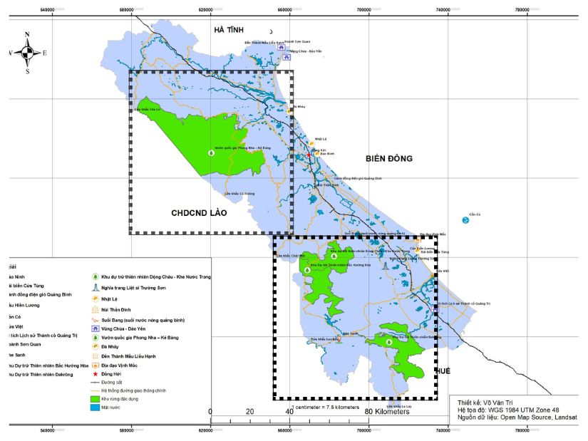 Vườn quốc gia và khu bảo tồn thiên nhiên miền tây Quảng Trị (mới)
2. Natural Values and the Role of National Parks & Nature Reserves in Ecotourism and Conservation
The new Western Quang Tri is home to the province’s richest natural resources – tropical forest ecosystems, dramatic karst cave systems, and exceptional biodiversity. Anchoring this landscape are the Phong Nha–Ke Bang National Park and a network of vital nature reserves such as Dong Chau – Khe Nuoc Trong, Bac Huong Hoa, and Dakrong. Together, they safeguard irreplaceable ecosystems while serving as the backbone of the region’s ecotourism development strategy.
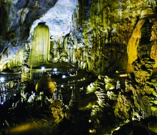
Phong Nha–Ke Bang National Park (Quang Binh) – a UNESCO World Heritage Site (2003) covering 123,326 hectares – is renowned as the “Kingdom of Caves”, home to about 1,000 caves including Phong Nha, Paradise, and Son Doong. Nearly 94% of its area is cloaked in pristine tropical limestone forest, sheltering around 2,900 plant species and over 1,300 animal species. The park has the highest diversity of primates in Vietnam (11 species) and numerous rare endemics. Beyond its ecological importance, the park regulates climate, safeguards water sources, and stands as a world-class ecotourism destination drawing visitors from across the globe.
Dong Chau – Khe Nuoc Trong Nature Reserve (Quang Binh) – established in 2020 and spanning 22,132 hectares – preserves some of the last remaining primary forests of the Truong Son Range. Its crystalline streams, caves, and high biodiversity make it a sanctuary for primates, forest birds, and endemic plants. Crucially, it forms an ecological corridor linking Phong Nha–Ke Bang with Quang Tri’s forest ecosystems, creating a continuous conservation landscape after the provincial merger.
Bac Huong Hoa Nature Reserve (Quang Tri) – covering nearly 23,500 hectares – embraces the province’s highest peak, Voi Mep (1,700m), dubbed the “Roof of Quang Tri”. Its altitudinal range (150–1,700m) fosters a spectrum of ecosystems from subtropical montane evergreen forest to tropical rainforest. Surveys record 1,327 plant species (156 rare) and 935 animal species (97 rare), including saola, Ha Tinh langur, red-shanked douc, Javan pangolin, and rare pheasants. As a headwater protection forest, it feeds the Ben Hai, Rao Quan, Hieu, and Se Pang Hieng rivers. With misty Sa Mu Pass, thundering Bac Waterfall, and the distinctive culture of the Van Kieu people, Bac Huong Hoa is a promising destination for adventure and cultural tourism.
Dakrong Nature Reserve (Quang Tri) – spread over 37,841 hectares – represents the low-elevation tropical forests of the Northern Truong Son block. Home to 1,412 plant species (24 in Vietnam’s Red Data Book) and 612 animal species (37 listed), its rugged terrain and cascading waterfalls make it ideal for community-based ecotourism, combining forest exploration with ethnic minority village experiences.
Collectively, the national parks and nature reserves of the new Quang Tri form an unbroken ecological network stretching from high mountain forests to offshore islands – a foundation for sustainable tourism, scientific research, and environmental education. Before the merger, Quang Binh’s nature-based tourism had already flourished, welcoming over 5 million visitors in 2024 with revenues of ~VND 6,000 billion, largely driven by Phong Nha–Ke Bang. Post-merger, the new Quang Tri can connect these western natural treasures with the eastern coastline’s historical sites and cultural landscapes, creating a unique “sea – forest – cave – history” tourism brand. Protecting the western special-use forests is therefore not just about biodiversity – it is about enabling sustainable livelihoods, fostering environmental awareness, and positioning Quang Tri as a premier ecotourism destination in Vietnam.
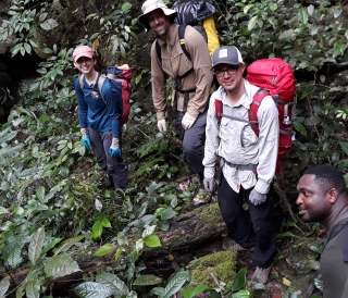
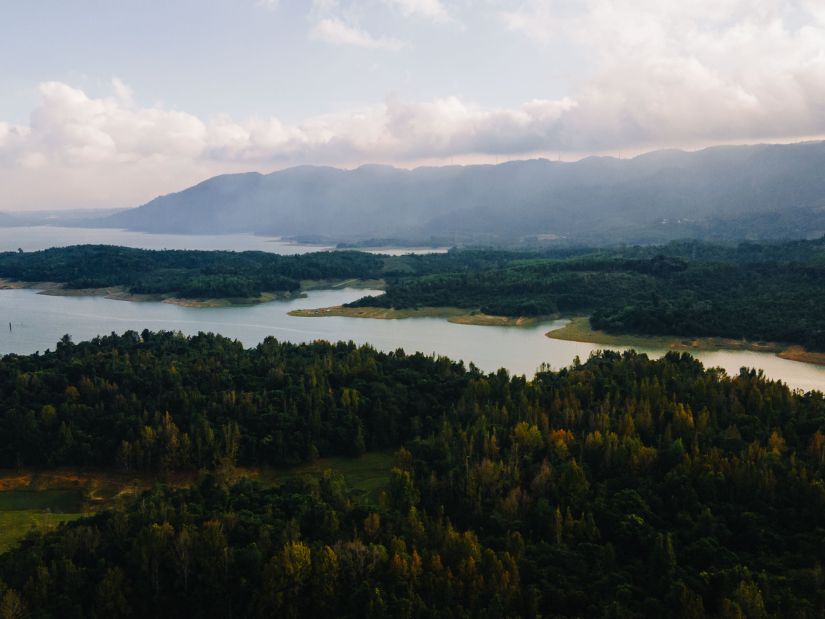 Western Quảng Trị’s Natural Landscapes
3. The Benefits of Establishing a UNESCO Biosphere Reserve in Western Quang Tri
With its outstanding natural and cultural values, Western Quang Tri fully meets the potential to be nominated as a UNESCO World Biosphere Reserve – an internationally prestigious title. Under UNESCO’s Man and the Biosphere (MAB) Programme, a site must meet seven rigorous criteria: representative ecosystems; significant biodiversity value; integration of sustainable development; sufficient scale to fulfill the three core functions (conservation, development, support); clearly defined zoning (core, buffer, and transition areas); effective governance; and suitable management, research, and education programmes.
Vietnam currently boasts 11 UNESCO Biosphere Reserves, ranking second in Southeast Asia after Indonesia. Many of these reserves have become exemplary models of sustainable development, harmonizing nature conservation with community benefits.
One striking example is the Western Nghe An Biosphere Reserve (recognized in 2007) – Vietnam’s largest, spanning nearly 1.3 million hectares across nine mountainous districts. With forest cover exceeding 60%, its core zone includes Pu Mat National Park and the Pu Huong and Pu Hoat Nature Reserves – sanctuaries for numerous rare and endemic species. This reserve has successfully preserved biodiversity, fostered a green economy, improved community livelihoods, and strengthened international cooperation in conservation and sustainable development – a living proof of the tangible benefits UNESCO status can bring.
A Western Quang Tri Biosphere Reserve would promise similar far-reaching benefits:
-
Sustainable Socio-Economic Development – UNESCO recognition would elevate Quang Tri’s profile, attract investment, boost tourism and services, and create jobs. The province could position tourism as a spearhead economic sector while ensuring resource conservation and long-term sustainability.
-
Mobilizing Resources for Conservation – International designation makes it easier to secure domestic and foreign funding for ecosystem protection, biodiversity monitoring, and community livelihood projects in buffer zones. Scientific research, biodiversity surveys, and community development initiatives would benefit from the global biosphere network’s support.
-
Advancing Ecotourism & Environmental Education – UNESCO status would catalyze ecotourism and community-based tourism, blending natural exploration with local cultural experiences. This approach ensures that local people benefit directly from conservation. The reserve would also serve as a “living laboratory” for scientific research and environmental education for future generations.
-
Expanding International Cooperation – Joining UNESCO’s network of over 700 biosphere reserves worldwide would connect Quang Tri with global models of sustainable development, enabling knowledge exchange, technical support, and training from leading conservation organizations.
-
Strengthening Nature & Cultural Heritage Protection – The reserve would safeguard the Truong Son Range’s unique ecosystems, species, and genetic resources, preventing biodiversity loss. It would also encourage preservation of indigenous cultures, fostering harmony between people and nature through research, awareness-raising, and sustainable management.
In essence, a Western Quang Tri Biosphere Reserve would be a transformative catalyst – protecting the province’s priceless natural assets while driving a sustainable economic future in balance with its cultural and environmental heritage.
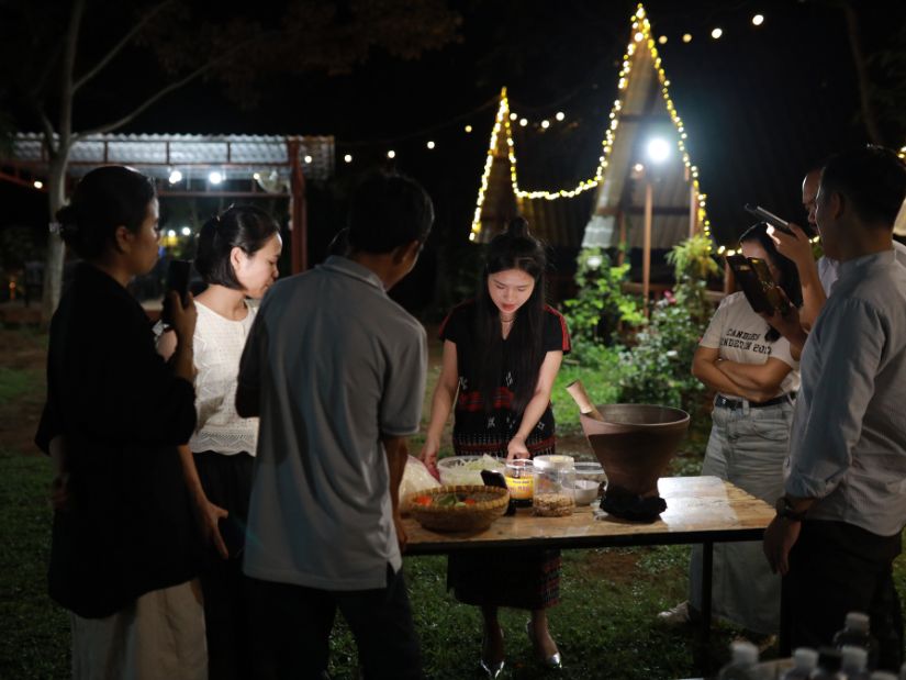 Vân Kiều Cuisine – A Taste of Cultural Beauty
4. A North–South Biosphere Reserve Linking Urban Hubs – A Green Engine for Growth
The newly merged Quang Tri Province enjoys an exceptionally strategic position along Vietnam’s vital North–South transport corridor. The North–South Expressway, National Highway 1A, and the Reunification Railway run the length of the province, passing through Dong Hoi (Quang Binh) and Dong Ha (Quang Tri), forming a coastal urban–transport spine. In parallel, the Ho Chi Minh Highway cuts through the mountains of Phong Nha and Khe Sanh (Eastern branch) and traces the Vietnam–Laos border (Western branch), creating a second North–South axis through the Truong Son Range. This places Western Quang Tri – the proposed biosphere reserve site – at the crossroads of both longitudinal routes (Ho Chi Minh Highway) and transversal links (Highways 9, 12A) to Laos and Thailand.
In the coming years, infrastructure upgrades will unlock even greater potential for the reserve’s buffer zones. The Eastern North–South Expressway segment through Quang Binh–Quang Tri is under construction and expected to open before 2026, enabling seamless travel from Ha Tinh to Thua Thien Hue. Meanwhile, the Cam Lo – La Son Expressway (Western route) is being built to connect Dong Ha to Hue. Upon completion, Quang Tri will sit on both North–South expressway corridors, making access to its western highlands easier than ever. Complementing this, the Dong Hoi – Quang Tri Airport pair (approx. 150 km apart, with Quang Tri Airport slated for post-2025 completion) will form a dual-airport network, offering rapid air access to both Phong Nha–Ke Bang and Dong Ha–Quang Tri destinations.
With such locational and infrastructural advantages, the Western Quang Tri Biosphere Reserve can serve as a green growth nucleus linking urban centers along the North–South corridor. Anchored by attractions such as Phong Nha, Khe Sanh, and Sa Mu Pass, the reserve would lie along a major domestic and international tourism route, connecting Dong Hoi in the north to Dong Ha and Hue in the south. Cities along this route will benefit from the surge in ecotourism, stimulating demand for hospitality, cuisine, and transport services. The reserve would thus catalyze a shift in local economic structure toward tourism and services, creating jobs and sustainable livelihoods.
Following the provincial merger, local authorities envision inter-provincial tour packages combining the UNESCO-listed Phong Nha–Ke Bang with Quang Tri’s historic war relics, shaping a signature “Sea – Forest – Caves – History” tourism brand to encourage longer stays rather than day trips. The biosphere reserve would be the centerpiece of this itinerary, offering travelers a diverse spectrum of experiences – from cave expeditions and pristine forest treks to cultural immersion in ethnic minority villages and visits to former battlefields – all in one journey.
Furthermore, the reserve’s proximity to border-gate economic zones (Lao Bao, Cha Lo) and its location on the East–West Economic Corridor positions it as a bridge for trade and tourism flows with Laos and Thailand. With effective branding, the Quang Tri Biosphere Reserve could attract international visitors from the Greater Mekong Subregion via National Route 9 (EWEC).
In essence, the Western Quang Tri Biosphere Reserve would not only connect conservation landscapes with urban growth nodes, but also unite nature protection with tourism and service sector development – a strategic driver for sustainable economic growth and an elevated regional profile.
 Sa Mù Pass – The Misty Gateway of the Trường Sơn Mountains
5. Conclusion
Establishing the Western Quang Tri Biosphere Reserve would be a strategic milestone – harmonizing the twin goals of conserving natural heritage and fostering sustainable development in the wake of the province’s expanded boundaries. This western highland region, with its ancient Truong Son forests, rich biodiversity, and distinctive cultural identity, fully deserves an internationally recognized designation that ensures both strict protection and sustainable value utilization.
Under the UNESCO Biosphere Reserve framework, Quang Tri could position itself as a land of exceptional natural and historical heritage, drawing investment, resources, and attention for local socio-economic growth. More importantly, the reserve would serve as a gift to future generations – safeguarding primeval forests, rare and endangered species, and indigenous cultural traditions from the pressures of urbanization and climate change.
In essence, creating the Western Quang Tri Biosphere Reserve is about turning the province’s inherent natural advantages into a driving force for green development, realizing the vision of a “New Quang Tri” that not only thrives locally but also contributes meaningfully to the global network of biosphere reserves and to sustainable growth for the entire region.
References
[1] Phong Nha Việt. “Tỉnh Quảng Trị mới: Tiềm năng phát triển từ hợp nhất Quảng Bình – Quảng Trị”, chuyên mục Sự kiện Môi trường – Nghiên cứu đa lĩnh vực, 06/2025. [Online]. Available: https://phongnhaviet.com/su-kien-moi-truong/nghien-cuu-da-linh-vuc/tinh-quang-tri-moi-tiem-nang-phat-trien
[2] Báo Quảng Trị. “Khu bảo tồn thiên nhiên Bắc Hướng Hóa: Điểm đến du lịch sinh thái tiềm năng”, 11/01/2025. [Online]. Available: baoquangtri.vn/khu-bao-ton-thien-nhien-bac-huong-hoa-diem-den-du-lich-sinh-thai-tiem-nang-191017.htm
[3] Quảng Nghĩa. “Quảng Bình: Thành lập Khu dự trữ thiên nhiên Động Châu - khe Nước Trong”, báo Đại Đoàn Kết, 30/06/2020. [Online]. Available: (3)/quang-binh-thanh-lap-khu-du-tru-thien-nhien-dong-chau-khe-nuoc-trong-10158619.html
[4] Nguyễn Nhàn. “Quảng Bình: Đề cử Phong Nha - Kẻ Bàng thành Khu dự trữ sinh quyển thế giới”, Tạp chí Công nghiệp Môi trường, 30/09/2024. [Online]. Available: (4)/quang-binh-de-cu-phong-nha-ke-bang-thanh-khu-du-tru-sinh-quyen-the-gioi-13894
[5] Quang An. “Triển khai đánh giá 10 năm và định hướng phát triển Khu Dự trữ sinh quyển miền Tây Nghệ An”, Báo Nghệ An, 30/05/2025. [Online]. Available: (5)/trien-khai-danh-gia-10-nam-va-dinh-huong-phat-trien-khu-du-tru-sinh-quyen-mien-tay-nghe-an-10298552.html
[6] Cục BTNTM&ĐDSH (Bộ TN&MT). “Khu dự trữ thiên nhiên Đakrông, Quảng Trị”, Trang thông tin Bảo tồn thiên nhiên và ĐDSH Việt Nam, 30/10/2023. [Online]. Available: nbca.gov.vn/khu-du-tru-thien-nhien-dakrong-quang-tri/
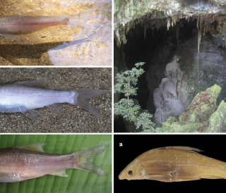
Thế giới động vật hang động Phong Nha – Kẻ Bàng
Khám phá thế giới động vật hang động Phong Nha – Kẻ Bàng: cá mù Hang Va, tôm càng Phong Nha, bọ cạp Thiên Đường, ốc nón Sơn Đoòng và các loài mới cho khoa học trong karst.
Đặc điểm và giá trị toàn cầu của hệ thống hang động karst Phong Nha – Kẻ Bàng
Phong Nha - Kẻ Bàng có tuổi karst cổ, cấu trúc nhiều hệ thống hang lớn, phân tầng và hình thái đa dạng của Phong Nha – Kẻ Bàng, đối chiếu với các di sản hang động tiêu biểu thế giới.
Karst Cave Formation: The Case of the Phong Nha–Ke Bang Limestone Massif
This article explores the karst cave formation process in the Phong Nha – Ke Bang limestone massif, highlighting geological stages shaped by water, tectonics, and tropical climate over millions of years.
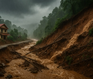
Hệ Thống Cảnh Báo Sớm: Lá Chắn Mềm Trước Thiên Tai
Trong bối cảnh khí hậu toàn cầu ngày càng nóng lên và các hiện tượng thời tiết cực đoan gia tăng, thiên tai ở Việt Nam đang gây thiệt hại nặng nề về người và tài sản. Bài viết phân tích vai trò của hệ thống cảnh báo sớm thiên tai như một “lá chắn mềm” giúp giảm nhẹ rủi ro